
Firstly, once again I’ve had to leave this blog to one side because of how busy I’ve been – so if you are a (the?) reader, I apologise for the lack of updates since (checks) 11th May this year. Actually, that’s not as bad as it has been in the past, so perhaps I should just delete this opening paragraph and ignore the intervening gap? 😉
Nah, it can stay!
And with that out of the way, the main subject of this post was going to be a walk I took a few days ago – but I realised that I’d intended to write about one back in May, to Avebury, and didn’t get around to it. I’ll therefore write about that one first, and put off the other day’s walk until another day.
Hopefully, though, it won’t get put off until the point that I want to write up the next one. 🙂
(And I am reminded by looking back at when I last wrote anything that I still need to finish off converting my Eurovision ‘tweets’ to a blog post, amongst other things. Ahem.)
Slightly amusingly, as I began to type this I spotted a file in my drafts folder called ‘Avebury.html’ – and I thought “Oh, I’ve already started writing about this walk. I’ll load that and move its contents to here…” However, on opening it I realised it was actually that 11th May post. I must have intended to write about the walk at the time, spotted how long it had been since my last post, then rambled on as a result of that.
I’ll ignore that, then, and just start now.
The key thing about my trip down to Avebury was that it went a little wrong – I came back slightly worse for wear, and not just in the sense that I was worn out.
Although I’ve driven through it on numerous occasions, I haven’t been to Avebury itself since I was at school – one of our school trips took us to Silbury Hill, West Kennet Long Barrow, and to the Avebury Stone Circle. All of them are within shouting distance of one another; you can park for one and walk between all three for a nice day out, with plenty to see and do.
I did visit the barrow back in 2006, but the reason I didn’t include Avebury was because it was at the tail end of a trip to Stonehenge – being on the way home I spent some time at West Kennet Long Barrow, but skipped the stone circle because the time was getting on and the light starting to fade.
My plan on the trip in May was to leave the car in the Silbury Hill car park, and walk a path that would take me around the back of the hill (from the road, the A4), along a path that runs alongside the River Kennet, then up and over Wadon Hill to the end of the avenue of stones leading to the main henge and circle.
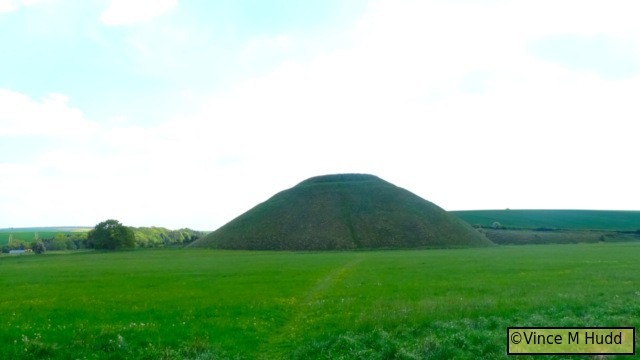
Of course, taking plenty of pictures along the way. Here’s one of Silbury Hill, for example.
It was a nice day, so my thinking was that route would have made a nice walk, with only one small climb (Wadon Hill) to contend with (well, two if you count the return). Given my lack of walks in recent years (i.e. almost none), I felt that would be ideal to help ease myself back in.
So, of course, while walking along the path by the River Kennet, I mis-stepped and twisted my ankle – and (I thought at the time) broke my camera when I fell.
That’s far from the first time I’ve twisted an ankle – I’ve done it to both more than once over the years, to the extent that I can sometimes get unexpected twinges from either. I tend to wear boots day to day – not just for trips out walking or hiking – for that very reason.
The last really bad twist was on the first day of a holiday in Tintagel and Boscastle, back in… ah, can’t find the pics, which would tell me when it was. They’ll be among the ones lost when my old network storage died, then. Being the first day of the holiday, the result was that I spent most of the week sat around in the place I’d rented, instead of getting out walking. That was fun, as well.
Meanwhile, back to the Avebury trip: I’ve just twisted my ankle on this walk, so what did I do?
Well, me being me, after a moment to recompose myself and let it rest, I carried on.
Soon after the twist, I went to take a photograph, and discovered that the image in the viewfinder was blurred. I took the picture anyway, and looking at the result via the LCD panel it seemed fine. Based on that, a quick test showed that the panel was fine for taking pictures with as well, but I greatly prefer the viewfinder. I could broadly see what I needed to that way – just not in focus – so I carried on using it, and just hoped that my framing etc would be fine.
(My approach tends to be to take a wider shot than my subject matter, knowing that it can be cropped as necessary if I ever want to use the picture in some way. So a blurry viewfinder wasn’t the end of the world – at least not for general shots out in the open. That wouldn’t work for anything more precise or up close, though – so at this point, I thought I’d need to replace the camera.)
Another annoyance (believing that I’d broken the camera aside) was that somewhere down the line I’d inadvertently switched on the option to stamp the date on the photographs – and on my camera, when it does that the text size is stupidly large in my opinion. I didn’t realise this until I returned home, though, and transferred the photos off the camera onto my computer. This didn’t happen when I fell – the photos from before then also include the date. It’s something I must have done without realising.
Back to the plot again: I reached the point on the path along the river that I had to turn left and head up and over Wadon Hill.
My ankle had been hurting quite a bit up to that point, but it had been nothing compared to how much it hurt as I climbed the hill. By the time I reached the top, it was basically screaming at me, saying “VINCE! TURN BACK, FFS!”
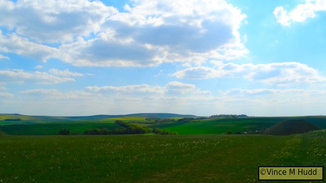
At the top I decided it was an ideal time to sit down and eat – in the hope that just resting my ankle for a bit would sort it out. It didn’t, but it was a nice spot to eat, with some nice views. In this photo taken from that spot, for example, you can see the top half of Silbury Hill on the right, and (very, very small) on the left is West Kennet Long Barrow.
Unless you know what you’re looking for, you might struggle to identify West Kennet Long Barrow in that picture, so making use of the camera’s zoom this next one offers a closer look at the barrow from the same point:
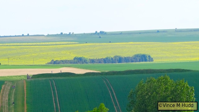
You can probably now more easily identify it in the previous picture. 🙂
Having taken a few pictures of the views all around, had a bite to eat, and most importantly rested that ankle, I got up and donned my rucksack…
And my ankle immediately started screaming at me again.
This time, I paid attention to it (up to a point), and rather than continue on towards Avebury I decided to head back the way I’d come – but I had a cunning plan. I limped my way back to the car, and drove around to a layby right next to the start of the two rows of stones that make up the West Kennet Avenue. I’d continue my wander towards Avebury from there!
In other words, I only listened to my ankle in the context of Wadon Hill – rather than carry on down the way I’d planned (which would have meant eventually climbing it again from the other side to return to the car), I made one descent then skipped around it!
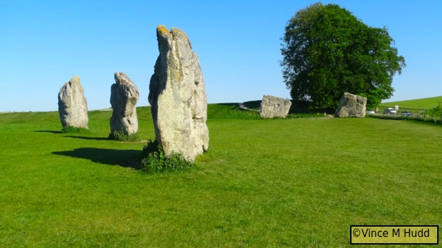
The avenue (or what remains of it) isn’t hugely long, but because I took rather a lot of photographs along the way (as usual), and especially coupled with my painful ankle, it felt a lot longer than it is.
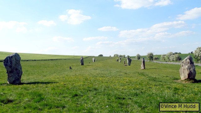
Eventually, of course, I reached the henge and stone circle.
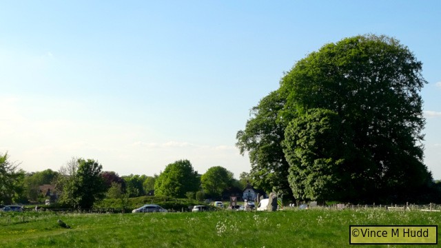
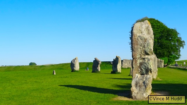
In that picture, where the large tree is on the right is a gate (after crossing the road) that leads in to that part of the henge area, with the stone circle inside of that. You can see part of the bank running across to the left of the picture (behind the cars) – and yes, the buildings you can see are the part of the village of Avebury that lies inside the stone circle.
The next picture is from inside the gate, where I was standing on the bank of earth that forms part of the henge, looking in towards the ditch and some of the stones (and the road that runs through).
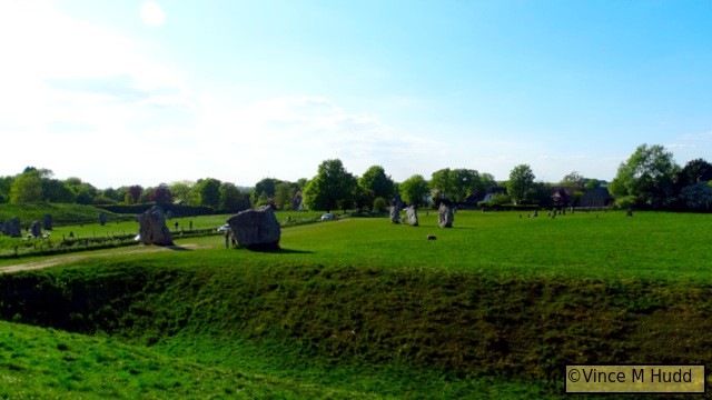
This picture highlights a few things about Avebury that could perhaps do with a little explanation. I don’t want to turn this into an educational post about different types of neolithic monument, or about Avebury itself, but to briefly clarify, if you look at the positions of all the stones visible in that picture, they clearly don’t seem to form a circle – and that’s because Avebury isn’t just made up of a single circle:
- The two very large stones just beyond the ditch are part of the outer circle, as are those visible at the very left of the frame, the line of which curves inwards in the picture.
- Within the main/outer circle, Avebury contains (or contained) two smaller inner circles, and there was once apparently a ‘cove’ made up of three additional standing stones. The other stones in the picture above form part of those inner monuments.
- In addition to that a geophysics survey – ground penetrating RADAR and similar tech – carried out in, I think, 2016 or 2017 revealed what appears to be signs of a much older, rectangular structure within the circle.
- The outer bank and ditch form the henge that encloses the broadly circular area, which contains the Avebury Stone Circle.
- And finally there are the avenues – I mentioned one above; the West Kennet Avenue that leads from the circle in one direction, not towards West Kennet Long Barrow, which you might assume from its name, but actually towards a site known as The Sanctuary, a smaller neolithic site. The other is known as Beckhampton Avenue, and led from Avebury towards a neolithic site known as The Longstones (near Beckhampton – hence the name). I believe only one stone remains of Beckhampton Avenue.
From more or less the same spot, this is the view in the other direction, showing more of the henge – the outer bank and ditch, curving inwards towards the left.
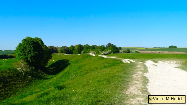
You’ll notice a lack of stones in that direction. I believe the Avebury monument once consisted of close to 200 stones, but the number there now is fewer than thirty.
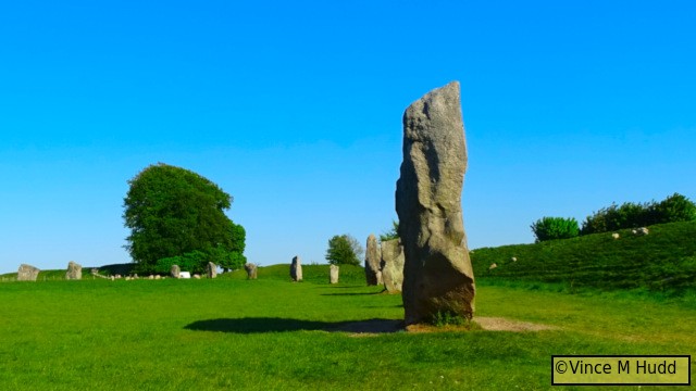
I wandered around this section of the site for a while, taking plenty of photographs, before crossing the road and ambling – er, limping – around another section. What I didn’t do (but probably would have if I hadn’t hurt my ankle) was wander around as much of the circle as I could. The whole thing is around 330 metres in diameter, with a circumference, therefore, of just over a kilometre – so adding that to the (planned) walk from Silbury Hill, and along the avenue, would ordinarily make an enjoyable and not at all taxing little trek – especially with a walk up to West Kennet Long Barrow thrown in as well.
I think, therefore, that at some point I need to head down there again – and probably again, and again. For now, though, I’ll finish this post with a very small selection of additional pictures from the day.
Before those pictures, to tie up a loose end – the camera, it turned out, wasn’t broken after all. The viewfinder has a little dial that can be used to adjust it, so that its user can set it in a way that’s suitable for their eyesight. I must have set it in the first place, when I bought it (and would probably have done similar on previous cameras) – but completely forgot back in May, so a quick thank you to Andrew Conroy who reminded me of it in a Facebook comment. (I guess that when I mis-stepped, I probably twisted not just my ankle, but also that dial!)